|
|
bool | ReadTileList (const char *dataset_fname_elev, const char *dataset_fname_image, bool bThreading, bool bGradual) |
| |
|
void | SetVerticalExag (float fExag) |
| |
|
float | GetVerticalExag () const |
| |
|
void | SetVertexTarget (int iVertices) |
| |
|
int | GetVertexTarget () |
| |
|
FPoint2 | GetWorldSpacingAtPoint (const DPoint2 &p) |
| |
|
void | SetTexLODFactor (float factor) |
| |
|
void | DoRender () |
| |
|
void | DoCalcBoundBox (FBox3 &box) |
| |
|
void | DoCull (const vtCamera *pCam) |
| |
|
bool | FindAltitudeOnEarth (const DPoint2 &p, float &fAltitude, bool bTrue=false) const |
| |
| bool | FindAltitudeAtPoint (const FPoint3 &p3, float &fAltitude, bool bTrue=false, int iCultureFlags=0, FPoint3 *vNormal=NULL) const |
| |
|
bool | CastRayToSurface (const FPoint3 &point, const FPoint3 &dir, FPoint3 &result) const |
| | Find the intersection point of a ray with the heightfield.
|
| |
|
databuf | FetchTile (const char *fname) |
| |
|
class miniload * | GetMiniLoad () |
| |
|
class minitile * | GetMiniTile () |
| |
|
class datacloud * | GetDataCloud () |
| |
|
void | SetPagingRange (float val) |
| |
|
float | GetPagingRange () |
| |
|
bool | CheckMapFile (const char *mapfile, bool bIsTexture) |
| |
|
void | SetProgressCallback (ProgFuncPtrType progress_callback) |
| |
|
void | SetBaseURL (const char *url) |
| |
| int | IsVisible (const FSphere &sphere) const |
| |
| int | IsVisible (const FPoint3 &point0, const FPoint3 &point1, const FPoint3 &point2, const float fTolerance=0.0f) const |
| |
| int | IsVisible (const FPoint3 &point, float radius) |
| |
| bool | IsVisible (const FPoint3 &point) const |
| |
|
void | ApplyMaterial (vtMaterial *mat) |
| |
|
vtGeode * | CloneGeode () |
| |
|
void | CloneFromGeode (const vtGeode *rhs) |
| |
| void | AddMesh (vtMesh *pMesh, int iMatIdx) |
| |
| void | RemoveMesh (vtMesh *pMesh) |
| |
| void | AddTextMesh (vtTextMesh *pMesh, int iMatIdx) |
| |
| uint | GetNumMeshes () const |
| |
| vtMesh * | GetMesh (int i) const |
| |
| vtTextMesh * | GetTextMesh (int i) const |
| |
|
virtual void | SetMaterials (const class vtMaterialArray *mats) |
| |
|
const vtMaterialArray * | GetMaterials () const |
| |
|
vtMaterial * | GetMaterial (int idx) |
| |
|
void | SetMeshMatIndex (vtMesh *pMesh, int iMatIdx) |
| |
| void | SetEnabled (bool bOn) |
| |
| bool | GetEnabled () const |
| |
|
void | SetCastShadow (bool b) |
| | Set this node to cast a shadow, if it is under a vtShadow node. Default is false.
|
| |
|
bool | GetCastShadow () |
| | Get whether this node casts a shadow.
|
| |
|
void | GetBoundSphere (FSphere &sphere, bool bGlobal=false) |
| | Get the Bounding Sphere of the node.
|
| |
|
void | SetOsgNode (osg::Node *n) |
| |
|
void | Initialize (const LinearUnits units, const DRECT &earthextents, float fMinHeight, float fMaxHeight) |
| |
| virtual void | SetEarthExtents (const DRECT &ext) |
| |
| int | PointIsAboveTerrain (const FPoint3 &p) const |
| |
| bool | ConvertEarthToSurfacePoint (const DPoint2 &epos, FPoint3 &p3, int iCultureFlags=0, bool bTrue=false) |
| |
| bool | ContainsWorldPoint (float x, float z) |
| |
|
void | GetCenter (FPoint3 ¢er) |
| |
|
void | SetCulture (CultureExtension *ext) |
| |
|
void | Initialize (const DRECT &extents, float fMinHeight, float fMaxHeight) |
| |
| bool | ContainsEarthPoint (const DPoint2 &p, bool bInclusive=false) const |
| |
| DRECT & | GetEarthExtents () |
| |
|
const DRECT & | GetEarthExtents () const |
| |
| void | GetHeightExtents (float &fMinHeight, float &fMaxHeight) const |
| |
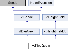
This class represents a tiled textured terrain heightfield, which is drawn using the tiled paging capabilities of Roettger's libMini. It is rendered directly using OpenGL, instead of going through OSG.

 Public Member Functions inherited from vtDynGeom
 Public Member Functions inherited from vtGeode
 Public Member Functions inherited from NodeExtension
 Public Member Functions inherited from vtHeightField3d
 Public Member Functions inherited from vtHeightField
 Public Attributes inherited from vtDynGeom
 Public Attributes inherited from vtGeode
 Public Attributes inherited from NodeExtension
 Public Attributes inherited from vtHeightField3d
 Protected Member Functions inherited from vtHeightField3d
 Protected Attributes inherited from vtDynGeom
 Protected Attributes inherited from vtHeightField3d
 Protected Attributes inherited from vtHeightField
 1.8.4
1.8.4